Aerial photography from an opened rear door Cessna 206 aircraft 2000 feet above Shark Bay (12 September 2022)

Aerial photography from an opened rear door Cessna 206 aircraft 2000 feet above Shark Bay (12 September 2022)

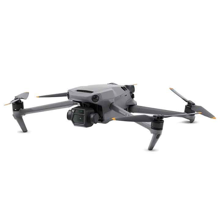
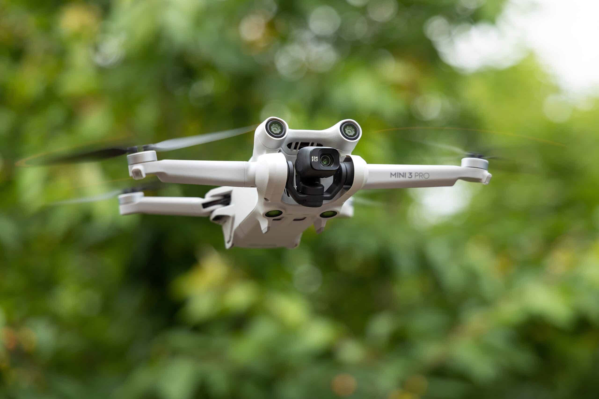
Drone photography with the help of two DJI drones which I think gave me really good image quality, each one finding its usefulness in different environments and situations. DJI™ drones are easy to fly, excellent software to manage your flights and images, most importantly to give you confidence in completing your task each time.
 Specifications of DJI Mavic 3 Drone 
Take off weight: 895g
Maximum flight time (no wind): 46mins
Maximum hovering time (no wind): 40mins
Maximum flight distance: 30kms
Maximum wind speed resistance: 12m/s
Camera: Hasselblad camera, 4/3 CMOS, 20MP sensor, f2.8 - f11
Specifications of DJI Mini 3 Pro Drone 
Take off weight: <249g
Maximum flight time (no wind): 34mins
Maximum hovering time (no wind): 30mins
Maximum flight distance: 18kms
Maximum wind speed resistance: 10.7m/s
Camera: Hasselblad camera, 1/1.3 inch CMOS, effective pixels 48MP sensor, f1.7
Cessna 206
Cessna 206
DJI Mavic 3
DJI Mavic 3
DJI Mini 3 Pro
DJI Mini 3 Pro
statues lake (11 october 2022)
kondinin, western australia

Taken from a DJI Mavic 3 drone at F5 and ISO 100 and using bracketed shots of 3.

statues lake (11 october 2022)
kondinin, western australia
Spot the iron sculpture in the lake. Created by a local Kondinin farmer, each of these statues made with recycled iron represents a typical work of the farming activity of the area. Taken from a DJI Mavic 3 drone at F5 and ISO 100 and using bracketed shots of 3.
statues lake (11 october 2022)
kondinin, western australia

Taken from a DJI Mavic 3 drone at F5 and ISO 100 and using bracketed shots of 3.

statues lake, kondinin (11 october 2022)
kondinin, western australia

Taken from a DJI Mavic 3 drone at F5 and ISO 100 and using bracketed shots of 3.

statues lake (11 october 2022)
kondinin, western australia

Taken from a DJI Mavic 3 drone at F5 and ISO 100 and using bracketed shots of 3.

Yenyening Lakes nature reserve (11 october 2022)
beverley, western australia
Unforgettable experience at this location during the spring season in Western Australia. Lots of flies and huge mosquitoes on constant attack while I was out in the open flying my drone! Taken from a DJI Mavic 3 drone at F5 and ISO 100 and using bracketed shots of 3. At this time, I was still new at flying a drone and this must be my very first few flights I have made so far!
Yenyening lakes are large salt lakes that are about 32km south east of Beverley. All the water from the Lockhart and Yilgarn Catchments flow through the Yenyening Lakes and into the Avon River from an area of 91000 square kilometres. Yenyening Lakes are a diverse ecosystem which provides habitats for flora, birds and wildlife. The lakes are a hotspot for photographers and astronomers with no light pollution making the perfect setting stargazing : quoted from Australia's.Guide Western Australia

Yenyening Lakes nature reserve (11 october 2022)

beverley, western australia

Taken from a DJI Mavic 3 drone at F5 and ISO 100 and using bracketed shots of 3.

Yenyening Lakes nature reserve (11 october 2022)
beverley, western australia

Taken from a DJI Mavic 3 drone at F5 and ISO 100 and using bracketed shots of 3.

Yenyening Lakes nature reserve (11 october 2022)
beverley, western australia

Taken from a DJI Mavic 3 drone at F5 and ISO 100 and using bracketed shots of 3.

Yenyening Lakes nature reserve (11 october 2022)
beverley, western australia
Yenyening Lakes nature reserve (11 october 2022) 
beverley, western australia

Taken from a DJI Mavic 3 drone at F5 and ISO 100 and using bracketed shots of 3.

Yenyening Lakes nature reserve (11 october 2022) 
beverley, western australia

Taken from a DJI Mavic 3 drone at F5 and ISO 100 and using bracketed shots of 3.

Yenyening Lakes nature reserve (11 october 2022)
beverley, western australia

Taken from a DJI Mavic 3 drone at F5 and ISO 100 and using bracketed shots of 3.

Yenyening Lakes nature reserve (11 october 2022)
beverley, western australia

Taken from a DJI Mavic 3 drone at F5 and ISO 100 and using bracketed shots of 3.

Yenyening Lakes nature reserve (11 october 2022)
beverley, western australia

Taken from a DJI Mavic 3 drone at F5 and ISO 100 and using bracketed shots of 3.

Yenyening Lakes nature reserve (11 october 2022)
beverley, western australia
Taken from a DJI Mavic 3 drone at F5 and ISO 100 and using bracketed shots of 3.
Yenyening Lakes nature reserve (11 october 2022) 
beverley, western australia

Taken from a DJI Mavic 3 drone at F5 and ISO 100 and using bracketed shots of 3.


the breakaways (12 october 2022)
norsemen, western australia
The unique Australian green eco friendly bush toilet can be seen just to the top left of this image. The Breakaways is located about 135kms to the east of Hyden on the Hyden-Norsemen Road, which is almost 2 hours drive on an unsealed road! Taken from a DJI Mavic 3 drone at F5 and ISO 100 and using bracketed shots of 3.
the breakaways (12 october 2022)
norsemen, western australia

Taken from a DJI Mavic 3 drone at F5 and ISO 100 and using bracketed shots of 3.

the breakaways (12 october 2022)
norsemen, western australia

Taken from a DJI Mavic 3 drone at F5 and ISO 100 and using bracketed shots of 3.

the breakaways (12 october 2022)
norsemen, western australia

Taken from a DJI Mavic 3 drone at F5 and ISO 100 and using bracketed shots of 3.

the breakaways (12 october 2022)
norsemen, western australia

Taken from a DJI Mavic 3 drone at F5 and ISO 100 and using bracketed shots of 3.

the breakaways (12 october 2022)
norsemen, western australia

Taken from a DJI Mavic 3 drone at F5 and ISO 100 and using bracketed shots of 3.

little lagoon (12 september 2022)
shark bay, western australia
Little Lagoon located near Denham, Shark Bay airport and Monkey Mia Resort. Taken from opened rear door of a Cessna 206 flying at 2000 feet.
Shark Bay is a World Heritage Site in the Gascoyne region of Western Australia. The 23,000-square-kilometre area is located approximately 800 kilometres north of Perth, on the westernmost point of the Australian continent. Wikipedia

little lagoon (12 september 2022)

shark bay, western australia

little lagoon (12 september 2022)
shark bay, western australia
little lagoon (12 september 2022)
shark bay, western australia
little lagoon (12 september 2022)
shark, bay, western australia
Little lagoon (12 september 2022)
shark bay, western australia
little lagoon (12 september 2022)
shark bay, western australia
little lagoon (12 september 2022)
shark bay, western australia
shark bay world heritage area, mid-west region of western australia (12 september 2022)
shark bay, western australia
shark bay world heritage area, mid-west region of western australia (12 september 2022)
shark bay, western australia
shark bay world heritage area, mid-west region of western australia (12 september 2022)
shark bay, western australia
shark bay world heritage area, mid-west region of western australia (12 september 2022)
shark bay, western australia
shark bay world heritage area, mid-west region of western australia (12 september 2022)
shark bay, western australia
the tree (12 september 2022)
shark bay, western australia
the tree (12 september 2022)
shark bay, western australia
the tree (12 september 2022)
shark bay, western australia
the tree (12 september 2022)
shark bay, western australia
the tree  (12 september 2022)
shark bay, western australia
the tree (12 september 2022)
shark bay, western australia
the tree (12 september 2022)
shark bay, western australia
the tree (12 september 2022)
shark bay, western australia
the tree (12 september 2022)
shark bay, western australia
the tree (12 september 2022)
shark bay, western australia

"the tree" region of shark bay unesco world heritage area, gascoyne region of Western Australia (12 september 2022)

shark bay. western australia

"the tree" region of shark bay unesco world heritage area, gascoyne region of Western Australia (12 september 2022)

shark bay, western australia

"the tree" region of shark bay unesco world heritage area, gascoyne region of Western Australia (12 september 2022)

shark bay, western australia

"the tree" region of shark bay unesco world heritage area, gascoyne region of Western Australia (12 september 2022)

shark bay, western australia

"the tree" region of shark bay unesco world heritage area, gascoyne region of Western Australia (12 september 2022)
shark bay, western australia
salt beds, useless loop (12 september 2022)
shark bay, western australia ​​​​
Salt mine in the Shark Bay region with images taken from above in an opened door Cessna 206 aircraft flying at 2000 feet. The Useless Loop area has 37 crystalliser ponds in various sizes and shapes, a salt-washing plant, a stockpile area and its own loading port.
Useless Loop is a town located on the Heirisson Prong on Denham Sound in the Southern Region of UNESCO World Heritage Site Shark Bay, Western Australia. The town of Denham is on the opposite shore of the sound and the more famous Monkey Mia near Denham. Wikipedia
salt beds, useless loop (12 september 2022)
shark bay, western australia ​​​​​​​
salt beds, useless loop (12 september 2022)
shark bay, western australia ​​​​​​​
salt beds, useless loop (12 september 2022)
shark bay, western australia ​​​​​​​
salt beds, useless loop (12 september 2022)
shark bay, western australia ​​​​​​​
salt beds, useless loop (12 september 2022)
shark bay, western australia ​​​​​​​
salt beds, useless loop (12 september 2022)
shark bay, western australia ​​​​​​​
salt beds, useless loop (12 september 2022)
shark bay, western australia ​​​
salt beds, useless loop (12 september 2022)
shark bay, western australia ​​​
salt lakes (13 october 2022)
holt rock, hyden, western australia
Taken from a DJI Mavic 3 drone at F5 and ISO 100 and using bracketed shots of 3.
salt lakes (13 october 2022)
holt rock, hyden, western australia
Taken from a DJI Mavic 3 drone at F5 and ISO 100 and using bracketed shots of 3.
salt lakes (13 october 2022)
holt rock, hyden, western australia

Taken from a DJI Mavic 3 drone at F5 and ISO 100 and using bracketed shots of 3.

salt lakes (13 october 2022)
holt rock, hyden, western australia
Taken from a DJI Mavic 3 drone at F5 and ISO 100 and using bracketed shots of 3.
salt lakes at mullet lakes nature reserve (14 october 2022)
esperance, western australia
Taken from a DJI Mavic 3 drone at F5 and ISO 100 and using bracketed shots of 3. Mullet Lake Nature Reserve covers an area of around 1,900 hectares and is located in the west of Australia. Mullet Lake Nature Reserve is in WA. Towns, villages or cities in and around Mullet Lake Nature Reserve include the town of Esperance
salt lakes at mullet lakes nature reserve (14 october 2022)
esperance, western australia

Taken from a DJI Mavic 3 drone at F5 and ISO 100 and using bracketed shots of 3.

salt lakes at mullet lakes nature reserve (14 october 2022)
esperance, western australia

Taken from a DJI Mavic 3 drone at F5 and ISO 100 and using bracketed shots of 3.

salt lakes at mullet lakes nature reserve (14 october 2022)
esperance, western australia

Taken from a DJI Mavic 3 drone at F5 and ISO 100 and using bracketed shots of 3.

pink lake no more (14 october 2022)
esperance, western australia
This lake has lost its pink colour due to a number of contributing factors including environmental and man made factors. Taken from a DJI Mavic 3 drone at F5.6 and ISO 100 and using bracketed shots of 3.
pink lake no more (14 october 2022)
esperance, western australia
Taken from a DJI Mavic 3 drone at F5.6 and ISO 100 and using bracketed shots of 3.
pink lake no more (14 october 2022)
esperance, western australia
Taken from a DJI Mavic 3 drone at F5.6 and ISO 100 and using bracketed shots of 3.
me, my car & mother nature (15 october 2022)
esperance, western australia
Woody Lakes Nature Reserve, Esperance, Goldfields-Esperance Region of Western Australia.
Area was carpeted with small yellow wild flowers during spring! Taken from a DJI Mavic 3 drone at F5 and ISO 100 and using bracketed shots of 3.
salt lakes at woody lakes nature reserve (15 october 2022)
esperance, western australia

Taken from a DJI Mavic 3 drone at F5 and ISO 100 and using bracketed shots of 3.

salt lakes at woody lakes nature reserve  (15 october 2022)
esperance, western australia
Taken from a DJI Mavic 3 drone at F5 and ISO 100 and using bracketed shots of 3.
 the golden dragon (16 october 2022)
denmark, western australia​​​​​​​
the golden dragon (16 october 2022)
denmark, western australia
Intriguing patterns created on the Wilson Inlet sandbank where the Denmark and Hay rivers meets the ocean in Denmark, Western Australia. Image taken from the Ocean Beach Lookout using a drone at F5.6 and ISO 100.
touch of green (23 november 2022)
damboring, western australia
Top down image of salt lakes taken in around the wheatbelt town of Damboring, located just off Northam-Pithara Road about 180kms north-northeast of Perth, Western Australia.  Taken from a DJI Mavic 3 drone at F4 and ISO 100 and using bracketed shots of 3.
ready for a fried egg? (23 november 2022)
damboring, western australia
Top down image of salt lakes taken in around the wheatbelt town of Damboring, located just off Northam-Pithara Road about 180kms north-northeast of Perth, Western Australia. Taken from a DJI Mavic 3 drone at F4 and ISO 100 and using bracketed shots of 3.
straight lines (23 november 2022)
damboring, western australia
Top down image of salt lakes taken in around the wheatbelt town of Damboring, located just off Northam-Pithara Road about 180kms north-northeast of Perth, Western Australia. Taken from a DJI Mavic 3 drone at F4 and ISO 100 and using bracketed shots of 3.
the serpent (23 november 2022)
damboring, western australia
Top down image of salt lakes taken in around the wheatbelt town of Damboring, located just off Northam-Pithara Road about 180kms north-northeast of Perth, Western Australia. Taken from a DJI Mavic 3 drone at F4 and ISO 100 and using bracketed shots of 3.
layers (23 november 2022)
damboring, western australia
Top down image of salt lakes taken in around the wheatbelt town of Damboring, located just off Northam-Pithara Road about 180kms north-northeast of Perth, Western Australia. Taken from a DJI Mavic 3 drone at F4 and ISO 100 and using bracketed shots of 3.
fire & ice (23 november 2022)
damboring, western australia
Top down image of salt lakes taken in around the wheatbelt town of Damboring, located just off Northam-Pithara Road about 180kms north-northeast of Perth, Western Australia. Taken from a DJI Mavic 3 drone at F4 and ISO 100 and using bracketed shots of 3.
salt lakes of reynoldson nature reserve (23 november 2022)
wongan hills, western australia
These salt lakes are located north-northeast of Wongan Hills, two and a half hour drive north of Perth, Western Australia. Taken from a DJI Mavic 3 drone at F4 and ISO 100 and using bracketed shots of 3.
salt lake (12 december 2022)
cranbrook, western australia
Top down image taken in around the wheatbelt town of Cranbrook, located 320kms south of Perth, Western Australia. Taken from a DJI Mavic 3 drone at F5.6 and ISO 100 and using bracketed shots of 3.
Cranbrook is a small town in the Shire of Cranbrook in the Great Southern region of Western Australia between KatanningKojonup and Mount Barker, situated 320 km south of Perth. It is billed as "The Gateway to the Stirlings", referring to the nearby Stirling Range National Park. At the 2006 census, Cranbrook had a population of 280. The settlement grew after it was one of the original railway stations on the Great Southern Railway when the railway opened in 1889, and was gazetted a townsite in 1899. The name is taken from the town of Cranbrook in KentEngland, about 65 kilometres south east of London. It is believed to have been named by Mr J A Wright, who was manager of the Western Australian Land Company which built the railway. The town is a Cooperative Bulk Handling receival site. Wikipedia.
fiery salt lake (12 december 2022)
cranbrook, western australia
Top down image taken in around the wheatbelt town of Cranbrook, located 320kms south of Perth, Western Australia. Taken from a DJI Mavic 3 drone at F5.6 and ISO 100 and using bracketed shots of 3.
salt lake (12 december 2022)
cranbrook, western australia
Top down image taken in around the wheatbelt town of Cranbrook, located 320kms south of Perth, Western Australia.  Taken from a DJI Mavic 3 drone at F5.6 and ISO 100 and using bracketed shots of 3.
eyeball optics (12 december 2022)
cranbrook, western australia
Top down image taken in around the wheatbelt town of Cranbrook, located 320kms south of Perth, Western Australia.  Taken from a DJI Mavic 3 drone at F5.6 and ISO 100 and using bracketed shots of 3.
eyeball optics (12 december 2022)
cranbrook, western australia
Top down image taken in around the wheatbelt town of Cranbrook, located 320kms south of Perth, Western Australia.  Taken from a DJI Mavic 3 drone at F5.6 and ISO 100 and using bracketed shots of 3.
mystic forest (12 december 2022)
cranbrook, western australia
Top down image taken in around the wheatbelt town of Cranbrook, located 320kms south of Perth, Western Australia.  Taken from a DJI Mavic 3 drone at F5.6 and ISO 100 and using bracketed shots of 3.
mystic forest(12 december 2022)
cranbrook, western australia
Top down image taken in around the wheatbelt town of Cranbrook, located 320kms south of Perth, Western Australia. Taken from a DJI Mavic 3 drone at F5.6 and ISO 100 and using bracketed shots of 3.
mystic forest (12 december 2022)
cranbrook, western australia
Top down image taken in around the wheatbelt town of Cranbrook, located 320kms south of Perth, Western Australia.  Taken from a DJI Mavic 3 drone at F5.6 and ISO 100 and using bracketed shots of 3.
Drone HDR panorama of Hutt Lagoon in Port Gregory, Western Australia
sea of pink (10 July 2023)
hutt lagoon, port gregory, western australia

The "Pink Lake Lookout" on Port Gregory Road with a small unsealed parking area is the best vantage point to view the pink lake. This is our second trip to this spot.

Taken at F11 ISO 100 from a DJI Mavic 3 drone, 3 bracketed shots each and manually composing the panoramic view. 
Salt Beds (10 July 2023)
hutt lagoon, port gregory, western australia
Taken at F11 ISO 100 from a DJI Mavic 3 drone, 3 bracketed shots each and manually composing the panoramic view. ​​​​​​​
Salt Beds (10 July 2023)
hutt lagoon, port gregory, western australia

Taken at F11 ISO 100 from a DJI Mavic 3 drone, 3 bracketed shots each and manually composing the panoramic view. ​​​​​​​
Abstract panorama of salt beds at Hutt Lagoon, Port Gregory, Western Australia
Salt Beds (10 July 2023)
hutt lagoon, port gregory, western australia

Taken at F11 ISO 100 from a DJI Mavic 3 drone, 3 bracketed shots each and manually composing the panoramic view. 
Abstract panorama of salt beds at Hutt Lagoon, Port Gregory, Western Australia
Salt Beds (10 July 2023)
hutt lagoon, port gregory, western australia
Taken at F11 ISO 100 from a DJI Mavic 3 drone, 3 bracketed shots each and manually composing the panoramic view. 
Abstract panorama of salt beds at Hutt Lagoon, Port Gregory, Western Australia
Salt Beds (10 July 2023)
hutt lagoon, port gregory, western australia
Taken at F11 ISO 100 from a DJI Mavic 3 drone, 3 bracketed shots each and manually composing the panoramic view. 
Salt Beds at Hutt Lagoon, Port Gregory, WA (10 July 2023)
hutt lagoon, port gregory, western australia
Taken at F11 ISO 100 from a DJI Mavic 3 drone, 3 bracketed shots each and manually composing the panoramic view. 
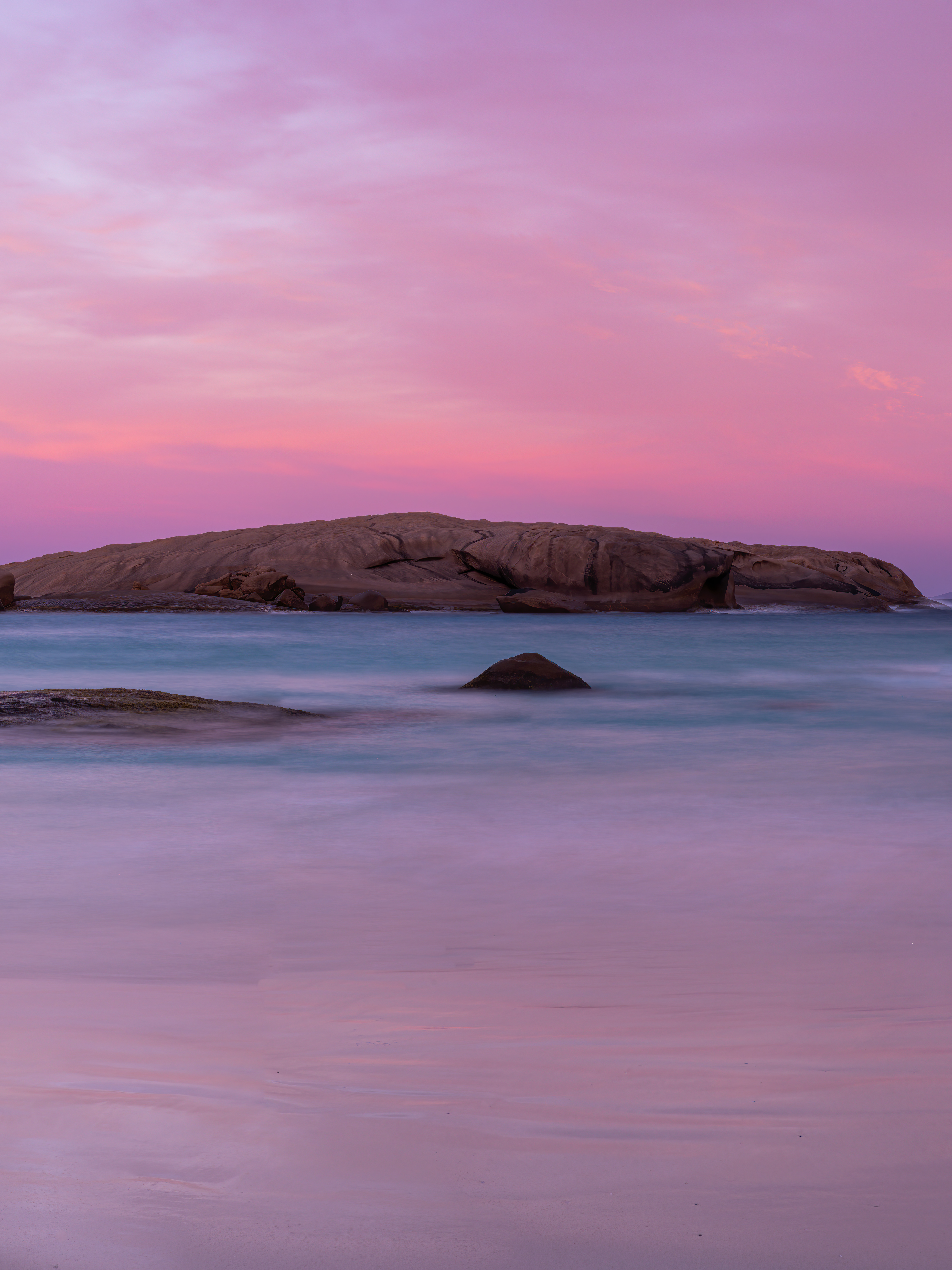
Hutt Lagoon is an elongate lake that sits in a dune swale adjacent to the coast. The town of Gregory is located between the ocean and the lake's southern shores. The road between Northampton and Kalbarri, George Grey Drive, runs along its eastern edge. The lake is about 14 km (9 mi) in length along its northwest-southeast axis, parallel with the coast, and around 2.3 km (1.4 mi) wide. Wikipedia
Salt Beds (10 July 2023)
hutt lagoon, port gregory, western australia
Taken at F11 ISO 100 from a DJI Mavic 3 drone, 3 bracketed shots each and manually composing the panoramic view. 

Salt Beds (10 July 2023)
hutt lagoon, port gregory, western australia
Taken at F11 ISO 100 from a DJI Mavic 3 drone, 3 bracketed shots each and manually composing the panoramic view. 
Salt Beds (10 July 2023)
hutt lagoon, port gregory, western australia
Taken at F11 ISO 100 from a DJI Mavic 3 drone, 3 bracketed shots each and manually composing the panoramic view. 
abAlone in salt (3 december 2023)
koorda, western australia
Taken at F11 ISO 100 from a DJI Mavic 3 drone, 7 sets of 5 bracketed shots each and manually composing the panoramic view. This salt lake is located on either side of Koorda-Dowerin Road and driving towards Koorda, just passed Rifle Range Road.
Koorda is a town in the north eastern Wheatbelt region of Western Australia, approximately 236 kilometres east of Perth and 43 kilometres north of Wyalkatchem at the northeastern end of the Cowcowing Lakes. It is the main town in the Shire of Koorda. At the 2016 census Koorda had a population of 414. Wikipedia
abAlone in salt (3 december 2023)
koorda, western australia
Taken at F11 ISO 100 from a DJI Mavic 3 drone and 5 bracketed shots for HDR effects. 
nambling lakes (3 december 2023)
dowerin, western australia
Taken at F11 ISO 100 from a DJI Mavic 3 drone and sets of 5 bracketed shots for HDR effects. This lake is located just of the intersection of Goomalling-Wyalkatchem Road and Nambling Road, towards Dowerin and past Goomalling.
Goomalling is a townsite in the Wheatbelt region of Western Australia, 45 kilometres north-north-east of Northam, Western Australia. The surrounding areas produce wheat and other cereal crops. The town is a receival site for Cooperative Bulk Handling. Wikipedia
Dowerin is a town 156 kilometres north-east of Perth in the central Wheatbelt region of Western Australia. It is the seat of the Shire of Dowerin. Wikipedia
cowcowing lakes (3 december 2023)
cowcowing, western australia
Taken at F11 ISO 100 from a DJI Mavic 3 drone and 8 sets of 5 bracketed shots for HDR effects. These lakes are located along Wyalkatchem-Koorda Road.
Cowcowing is a small town located just off the Koorda–Wyalkatchem road 215 kilometres from Perth, 24 kilometres south of Koorda and 23 kilometres north of Wyalkatchem in the Wheatbelt region of Western Australia. The town originated as a railway siding and was later gazetted as a townsite in 1919. Wikipedia

You may also like

Back to Top